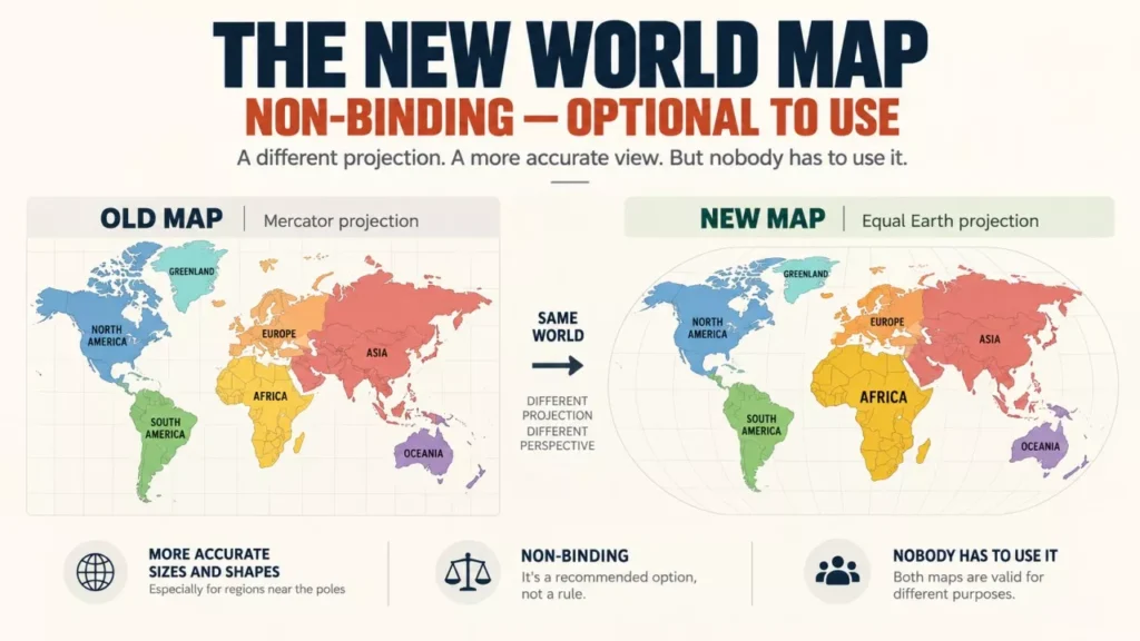

The United Nations General Assembly has endorsed a new world map. On 4 September 2026 it adopted resolution A/80/L.104, “Correct the map”, by 164 votes to 1 with 6 abstentions, urging wider use of the Equal Earth projection. The resolution is non-binding, and the United States voted against it.
What the United Nations Actually Voted For
The Assembly adopted a text calling for wider use of equal-area map projections, particularly Equal Earth, in contexts where the comparative size of continents matters. Its full title is “Correct the map: rebalancing global cartographic representation and promoting equitable representation of the world’s regions, particularly Africa”.
According to the Assembly’s official meeting record, the recorded vote was 164 in favour, 1 against and 6 abstentions. The United States cast the only vote against. Estonia, Georgia, Lithuania, the Republic of Moldova, Serbia and Ukraine abstained.
Togo sponsored the resolution on behalf of African States, and France co-sponsored it. Togo’s representative told the Assembly that “a fair map does not change the geography of the world; it changes how we see the world”. The United States representative dismissed such resolutions as “barnacles on our work here and the reason this institution is losing its credibility”.
What the resolution does not do matters as much as what it does. It does not ban the Mercator projection, does not declare Equal Earth an official world map, and does not apply to maritime or aerial navigation, where Mercator’s properties remain useful. It creates no deadline and no obligation on any government, school, publisher or technology company.
Why the Mercator Map Makes Africa Look Small
The Mercator projection distorts area because it was never designed to preserve it. The Flemish cartographer Gerardus Mercator published it in 1569 as a navigation tool: it renders a constant compass bearing as a straight line, which is what a sailor needs, at the cost of inflating landmasses as they approach the poles.
The most cited consequence is Greenland. Africa is roughly 14 times larger than Greenland, yet on a Mercator map the two appear close to the same size. That comparison was used by the campaign behind the resolution and repeated by France’s foreign minister, Jean-Noël Barrot, on the day of the vote.
Al Jazeera published the following regional land areas alongside its coverage of the vote on 5 September 2026. These are single-source figures for the purposes of this article.
| Region | Land area (million sq km) |
|---|---|
| Africa | 30.3 |
| Latin America | 20.0 |
| Europe | 10.2 |
| Oceania | 8.5 |
| South Asia | 5.1 |
Equal Earth was created in 2018 by the cartographers Bojan Šavrič, Tom Patterson and Bernhard Jenny. It preserves relative area and accepts curved meridians in exchange, so straight-line bearings are lost. Every flat map of a round planet distorts something; the argument at the UN was about which distortion to accept by default.
Who Has Adopted the New World Map So Far
Endorsement and adoption are not the same thing, and the gap between them is where this story currently sits. The table below records what each body has actually done, rather than what the resolution encourages.
| Body | Position | Date |
|---|---|---|
| UN General Assembly | Urges wider use of Equal Earth and other equal-area projections; non-binding | 4 September 2026 |
| African Union | Adopted Equal Earth for its own use and backed the Correct the Map campaign | Assembly session, 2026 |
| France (foreign ministry) | Dropping Mercator from ministry materials; reported to have chosen Eckert IV, not Equal Earth | Announced 4 September 2026 |
| United States | Voted against the resolution | 4 September 2026 |
| Major mapping platforms | No announced change to the projection they use | As of 8 September 2026 |
France is the clearest illustration. It co-sponsored a resolution promoting Equal Earth, but its own foreign ministry did not adopt Equal Earth. Euronews and Connexion France both reported that the ministry is moving to Eckert IV, an equal-area projection published in 1906. The ministry’s own statement, quoted by France 24, said only that it “will abandon the Mercator projection in favour of map representations tailored to specific uses, more faithful to actual surface areas and in line with the recommendations of cartographers and scientists”.
The change covers French diplomatic communications and ministry materials. Euronews reported that French schools still predominantly use Mercator maps, and that the ministry had begun phasing Mercator out of its public diplomacy websites in 2021.
As of 8 September 2026, no major mapping platform had announced a change to the projection used in its products, and no commitment from Google, Apple or any other platform could be verified for this article.
The Other Map Fight Is About Names, Not Shapes
While the projection debate ran at the UN, a separate change to the map has already taken effect for some users: what places are called. On 20 January 2025 an executive order titled “Restoring Names that Honor American Greatness” directed US federal agencies to rename the Gulf of Mexico as the Gulf of America and to restore the name Mount McKinley to the Alaskan peak officially named Denali since 2015. The US Department of the Interior said the federal names database had been updated the following month.
That authority stops at the US border. In the United States, place names are standardised by the US Board on Geographic Names, part of the US Geological Survey. Internationally there is no equivalent. As Innisfree McKinnon, Associate Professor of Geography at the University of Wisconsin-Stout, wrote in The Conversation, “there is no international board in charge of place names. Each country decides what to call places.”
The result is a single body of water with more than one name in active official use:
- US federal use: Gulf of America, in the federal names database since February 2025.
- Mexico and Cuba: Gulf of Mexico. The gulf borders all three countries.
- Google Maps: users in the United States see Gulf of America, users in Mexico see Gulf of Mexico, and users elsewhere see both.
- International Hydrographic Organization: its reference work Limits of Oceans and Seas has not been republished since 1953, in part because of an unresolved dispute over the Sea of Japan and East Sea.
Mexico’s president, Claudia Sheinbaum, has argued that the US order can apply only to the portion of the continental shelf under US control, and that renaming Mexican and Cuban waters is a separate matter. Mexico filed a civil suit against Google’s Mexican subsidiary in a Mexico City court seeking removal of the label. This article could not verify the current stage of that case, and Google has publicly declined to comment on it.
The Denali change met domestic resistance as well: on 7 February 2025 the Alaska State Legislature passed a joint resolution urging the federal government to keep Denali as the mountain’s official name.
Why Six Countries Abstained
The abstentions came from states with contested territory, and at least one said so on the record. According to the Assembly’s meeting record, Ukraine objected that Equal Earth political maps depict occupied territories “in a manner that is wholly unacceptable”.
The distinction matters. A projection determines the shape and relative size of landmasses, not who owns them. The resolution does not alter any border, sovereignty claim or the legal status of any disputed territory, and nothing in it settles a territorial dispute in any direction.
The Map Is Also Changing on the Ground
Beyond projections and names, the physical outline of the world is being redrawn by ice loss. A study published in the journal Nature Climate Change in 2025, led by Jan Kavan of the Centre for Polar Ecology at the University of South Bohemia, found that retreating marine-terminating glaciers exposed about 2,500 km of new Arctic coastline between 2000 and 2020, an average of 123 km a year, and revealed 35 new islands. The researchers assessed more than 1,700 glaciers across Greenland, Alaska, the Canadian Arctic, the Russian Arctic, Iceland and Svalbard, and reported that 85% of them retreated over the period. These figures are as reported by Carbon Brief.
A newly confirmed island is now being added to official charts. Between 8 February and 8 April 2026, the research icebreaker Polarstern, operated by Germany’s Alfred Wegener Institute, confirmed an island in the north-western Weddell Sea near Joinville Island, Antarctica. It measures roughly 130 metres long and 50 metres wide and rises about 16 metres above the water. It had appeared on nautical charts only as an area with unexplored dangers to navigation, and its ice cover made it hard to distinguish from icebergs on satellite imagery. The institute said the island will be added to international nautical charts and other datasets once the official naming procedure is complete; no name and no exact coordinates have been published yet.
Slower geological change is reshaping the map on a far longer timescale, as with the tectonic rift gradually splitting Africa, while ice loss is already altering measurements of the planet itself, including how polar melting affects Earth’s rotation.
What Happens Next
Nothing in the resolution takes effect on a set date, because nothing in it is required. Al Jazeera reported that Togo aims to revise school geography materials by the end of this year and will press governments, schools, international organisations and technology companies to follow. CNN reported that Togo plans a meeting in Lomé early next year, with UNESCO, the African Union and technology companies including Google, to work out what implementation looks like in practice; that meeting was reported by CNN alone among the sources reviewed here.
Three things remain unsettled. No mapping platform has committed to a change. No mechanism exists to monitor whether member states act. And the resolution’s own carve-out for navigation means Mercator and its web variants will remain in use regardless of how many governments adopt an equal-area map for teaching and publishing.
Frequently Asked Questions
What Is the New World Map the UN Backed?
It is the Equal Earth projection, an equal-area world map created in 2018 by cartographers Bojan Šavrič, Tom Patterson and Bernhard Jenny. On 4 September 2026 the UN General Assembly urged wider use of it and other equal-area projections where the comparative size of continents matters.
Does the Resolution Ban the Mercator Projection?
No. The resolution is non-binding and explicitly does not ban Mercator or impose a replacement. It also carves out maritime and aerial navigation, where the Mercator projection remains in use.
Does the New World Map Change Any Borders?
No. A map projection changes the shape and relative size of landmasses, not sovereignty. The resolution does not alter any border or the legal status of any disputed territory.
Which Countries Voted Against or Abstained?
The United States cast the only vote against. Estonia, Georgia, Lithuania, the Republic of Moldova, Serbia and Ukraine abstained, according to the UN’s official meeting record of the 4 September 2026 vote.
Has Google Maps Switched to Equal Earth?
No such change had been announced as of 8 September 2026, and no commitment from Google or any other mapping platform could be verified for this article. The resolution does not require technology companies to act.