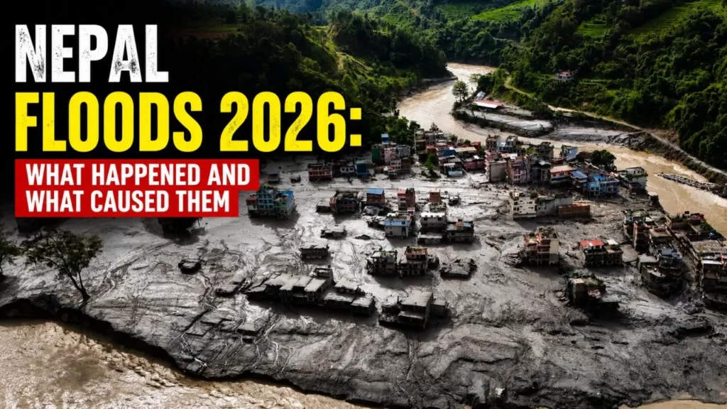

The Nepal floods of 26 August 2026 were caused by a glacier collapse on the Tibet border, not by monsoon rain. A mass of ice and rock fell into a Himalayan river, dammed it, then released it downstream. More than 500 people were killed and about 1,000 are still missing.
What Happened On The Morning Of 26 August
At about 8:37 a.m. local time on Wednesday 26 August, seismometers across the region picked up a sharp jolt near the Nepal–China border, roughly 55 km north-west of Kodari. It was not an earthquake. A large section of glacier had torn loose high on the flanks of Langtang Lirung and fallen into the valley below.
The ice and rock landed in the Lhende Khola, a small tributary that feeds the Bhote Koshi and, further down, the Trishuli. Floodwater reached the Gyirong Port border crossing on the Chinese side roughly seven minutes later. On the Nepali side, the surge tore through Timure, Syaphrubesi and Dhunche in Rasuwa district before running on through Nuwakot and Dhading.
Survivors described the river rising about nine metres — close to 30 feet — in under half an hour. Video recorded by residents shows a brown, boulder-laden wall of water rather than a rising river, which is why so few people in its path had time to climb. The surge was still doing damage some 240 km downstream, near Galchhi.
What Caused The Nepal Floods
Three separate mechanisms stacked on top of each other. Understanding the order matters, because it explains why a disaster of this size arrived on a clear morning with no rainfall warning in force.
A Glacier Sheared Off Langtang Lirung
Preliminary analysis points to a glacier detachment: a slab of ice roughly 610 metres wide broke away and dropped around 1,200 metres. Jakob Steiner, a geoscientist at the University of Graz, described the lower part of the glacier tongue shearing off after the rock beneath it failed, leaving the ice with nothing to sit on. By his account the mass fell from about 5,100 metres to 3,000 metres.
A detachment behaves less like a landslide and more like an avalanche of concrete. Friction melts part of the ice on the way down, and the resulting slurry picks up sediment, boulders and river water as it goes, arriving downstream with far more volume than the glacier itself contained.
The Debris Dammed The River, Then Let Go
The debris did not simply pass through. It blocked the Lhende Khola, holding water back for a period before the makeshift dam failed. That is the amplifier. A river held and then released in one go delivers a far more violent pulse than the same water flowing normally, and it is the reason communities more than 100 km away were affected by an event that began in a single side valley.
Why This Was Not A Glacial Lake Outburst Flood
Nepal has around 2,000 glacial lakes, and a glacial lake outburst flood — a GLOF — is the hazard most people in the region have been trained to fear. This was not one. There is no evidence that a pre-existing lake burst. The water came from ice melted by the impact itself, water already held in valley sediments, and the river that was dammed and released.
The distinction is not academic. GLOF monitoring watches known lakes. A glacier that detaches from a slope nobody was monitoring produces the same result with none of the same warning.
Why It First Looked Like An Earthquake
Early bulletins reported a magnitude 4.4 earthquake, later revised upward, and many first reports treated the quake as the cause. The United States Geological Survey then analysed the long-period seismic waves and found them consistent with a mass of rock and ice hitting the ground, not with a tectonic rupture. The signal did not precede the collapse; it was generated by it. A second, smaller signal about three hours later was consistent with a follow-on landslide.
The Death Toll, And Why Every Outlet Reports A Different Number
As of Friday 28 August, Nepal Police put the confirmed dead in Nepal at 547. Other counts published the same day range from roughly 470 to over 560, and the number is still moving. In Tibet, Chinese authorities have confirmed five deaths.
The spread is not carelessness. Different organisations are counting different things at different moments:
- Bodies recovered versus deaths confirmed and registered — recovery in the Trishuli gorge is running well ahead of formal identification.
- Nepal only versus Nepal plus Tibet, which some wires combine into a single regional figure.
- District tallies versus the national disaster authority’s consolidated count, which lags by hours.
The missing figure is harder still. Around 1,000 people are unaccounted for on the Nepali side by most counts, with some police tallies running considerably higher because they include travellers whose whereabouts simply have not been verified. Among them are roughly 700 foreign nationals from more than 30 countries — the border crossing is a busy trekking and trade route, and hundreds of vehicles were queued at Rasuwagadhi when the water arrived. Indian, American, Australian and British nationals are among the largest groups reported missing, though per-country numbers remain provisional. On the Chinese side, 558 people are listed missing, including 260 foreigners. Around 3,750 people have been rescued.
Where The Damage Landed
Rasuwa, a district of about 50,000 people, took the worst of it, followed by Nuwakot and Dhading, with effects registered as far down as Gorkha and Chitwan. The IFRC estimates at least 93,000 people have been affected.
The Rasuwagadhi–Gyirong crossing, Nepal’s main northern trade artery with China, was destroyed along with the customs facilities on both sides. More than 300 vehicles waiting at the border were swept away. Dozens of bridges are gone and tens of kilometres of road have been cut, with initial official estimates putting road and bridge damage alone at around Rs 15 billion.
Six hydropower facilities on the Trishuli system were hit, among them Rasuwagadhi, Chilime, Trishuli 3A and Devighat. Roughly 431 megawatts have come off the national grid, and a further 470 megawatts of projects still under construction were damaged — a serious blow for a country that has spent a decade building its way out of load-shedding. UNICEF reports 18 schools destroyed and 20 damaged, affecting around 10,000 children.
The Second Flood Threat On The Border
The debris that caused the disaster also created a new one. A barrier lake formed behind the deposits near the confluence of the Chhochen Khola and Purepu Tsangpo, on the Lhende river system at the border. China’s Ministry of Water Resources estimated it at 1.5 to 2 million cubic metres, with as much as 3 million cubic metres more expected to drain into it over three days.
Because the lake was held back only by loosely packed rock and ice, a sudden failure was the fear rather than a slow overflow. On Friday 28 August the lake breached. Rasuwa Chief District Officer Narendra Pariyar confirmed the Nepali Army had reported the breach, rescue work was briefly suspended, movement was restricted along key highways, and residents in exposed stretches of the Trishuli valley were moved to higher ground. Helicopters based at Dhunche were sent up for reconnaissance before crews returned to the riverbed.
Why No Warning Reached The Valley In Time
An early-warning arrangement between Nepal and China does exist on this river. It did not help. The system leans on water-level monitoring, which works for monsoon floods that build over hours and is far less dependable for a flash surge that arrives in minutes. Geologists have also described this particular stretch as a monitoring blind spot — attention had gone to the catalogued glacial lakes, not to the slope that failed.
Even a working system faces a brutal constraint here. With seven minutes between the collapse and the border, and half an hour to the towns below, warning has to be automatic, sensor-triggered and loud. Anything routed through an office is too slow.
The Bigger Picture In A Warming Himalaya
Scientists have been careful to say that no attribution study has yet linked this specific collapse to climate change, and that such a study takes months. What they will say is that the conditions are changing in one direction. Glaciers in the Hindu Kush Himalaya lost ice about 65 percent faster between 2011 and 2020 than in the decade before, and Nepal has lost roughly a third of its ice volume in 30 years.
Kristen Cook of Grenoble Alpes University points to melting permafrost destabilising slopes that were frozen solid for centuries. Dan Shugar of the University of Calgary expects these cascading events to become more frequent through some mix of glacier melt, permafrost thaw and shifting precipitation. Steiner was blunter, calling what happened the new normal and warning it gets worse from here. Kamal Kishore, who heads the UN Office for Disaster Risk Reduction, said that in living memory there had not been a mountain hazard event on this scale.
The same valley saw glacial lake flooding in 2025, an ice and rock avalanche struck nearby in 2024, and the 2015 earthquake buried the village of Langtang under an avalanche. This is not an isolated event in an otherwise stable landscape.
Where Things Stand On 28 August 2026
Search and rescue continues along a 72 km stretch of the Trishuli. Nepal has mobilised 13,295 security personnel — 7,250 police, 4,200 army and 1,845 Armed Police Force — and the army has lifted more than 350 people out by helicopter. Twenty-eight police officers are themselves among the missing.
Prime Minister Balendra Shah, in office since March, travelled to flood-hit Bidur in Nuwakot on 27 August, ordered free treatment for the injured and immediate relief for displaced families, and his cabinet has pledged a month’s salary to the relief fund. The affected districts have been declared disaster zones for three months.
International help is arriving: $2 million from the UN’s Central Emergency Response Fund, CHF 1 million from the IFRC, 50 tonnes of supplies from India, £5 million pledged by the United Kingdom, $1 million from South Korea and $500,000 plus a disaster response adviser from the United States. WHO has sent medical kits sized for 10,000 people for three months, and satellite tasking has been activated to map the valley from above.
With the barrier lake breached and more water still draining into the upper catchment, the immediate risk downstream has not passed. Figures in this article reflect what was confirmed on 28 August 2026 and will change as recovery continues.
Frequently Asked Questions
What Caused The Nepal Floods In August 2026?
A glacier detachment near Langtang Lirung on 26 August 2026 dropped a large mass of ice and rock into the Lhende Khola, a tributary of the Bhote Koshi and Trishuli. The debris dammed the river briefly, and the release produced the flash flood. It was not caused by monsoon rain.
Was This A Glacial Lake Outburst Flood?
No. There is no evidence that a glacial lake burst. The water came from ice melted during the collapse, water held in valley sediment and the river itself after debris dammed and then released it.
How Many People Died In The Nepal Floods?
Nepal Police reported 547 confirmed deaths in Nepal as of 28 August 2026, with five deaths confirmed in Tibet. Around 1,000 people remain missing and the toll is still rising.
Which Areas Of Nepal Were Affected?
Rasuwa district was worst hit, particularly Timure, Syaphrubesi and Dhunche, followed by Nuwakot and Dhading. Effects reached downstream into Gorkha and Chitwan along the Trishuli, and across the border into Gyirong County in Tibet.
Is There Still A Flood Risk In The Trishuli Valley?
Yes. A barrier lake formed by the debris breached on 28 August 2026, and more water is still draining into the upper catchment. Authorities have restricted highway movement and moved residents from exposed areas.
Was The Nepal Flood Caused By Climate Change?
No formal attribution study has been completed for this event. Scientists say Himalayan glaciers are losing ice roughly 65 percent faster than in the previous decade and that permafrost thaw is destabilising slopes, which makes collapses of this kind more likely over time.